2.1 Purpose of the Study
The purpose of this study is to develop a
comprehensive GIS database for Quail Hollow State Park to supply park managers
with planning scenarios for land acquisition. By acquiring
lands for animal and vegetation habitat, or establishing preserved
areas in close proximity to the park, sensitive habitats can
be buffered from increasing development near park boundaries. While
there is no current empirical evidence that Quail Hollow suffers from biodiversity
loss, the park does fit the criteria of an isolated "green island" (Noss
1993). The 700 acre park (1.1 square miles) is surrounded by agricultural
and residential development that may have negative impacts on important
environmental links. Establishing connectivity of habitat and
ecosystems may stimulate species populations and reduce loss of endangered
species or species at risk.
The development of a real-world model
utilizing GIS functions and analytic procedures can serve as a tool for
meeting the demands of natural resource and environmental planning
(Parks 1993). The objectives are not simply duplicating manual
procedures of park managers to a computerized environment -- although this
alone is an important technological progress.
This thesis explores two of the major problems
in the creation of a GIS for Quail Hollow State Park; 1) obtaining digital
data and conversion of the data into an accurate and useful database with
sufficient accuracy and 2) practical application of the GIS as an effective
decision-making tool.
The popular GIS software packages ARC/INFO
and ARCVIEW (ESRI 1995) were used for creation, assembly
and manipulation of the data. The use of ARC/INFO and
ARCVIEW on both UNIX and PC platforms for data assembly is explained in
detail in chapters V, VI and VII.
2.2 Problem 1: Data Acquisition and Conversion
The problems in applying GIS to park planning
are the acquisition and conversion of data, the formulation of the GIS
data layers, and most importantly, presenting the data in a useful and
meaningful manner. Integrating data into a comprehensive GIS
database allows the identification of current park management units, i.e.,
plant, animal and wetland communities. These units can be measured
within GIS data layers by area, perimeter and proximity to one another
as well as their spatial relationship between each other. For example,
some areas within Quail Hollow State Park (i.e. the study site) are bog
or wetland marsh. Using a GIS, a query of wetland marsh by area and perimeter
takes just a few minutes. In addition, the GIS database can be updated
easily when changes are necessary.
The accumulation of data is the most time
consuming process when creating a GIS. Data acquisition, data conversion,
and data integration techniques (Fisher 1991) are a problem focus
of this thesis. Careful and detailed planning of construction
of the databas is necessary to ensure the effectiveness of a precise and
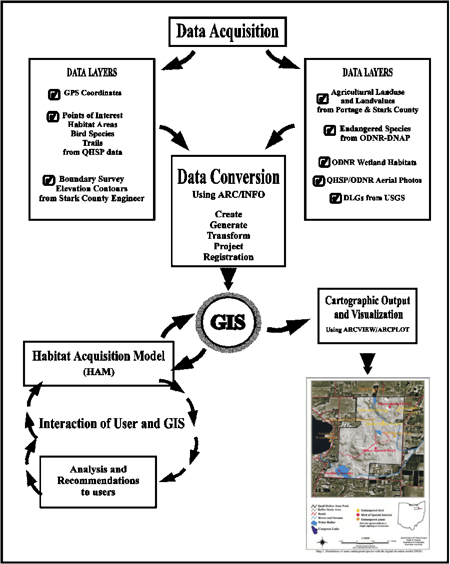
accurate GIS operation. The planning steps of the Quail Hollow State
Park GIS project are shown in Figure 3.
First, it is necessary to consider what type
of data are already in digital format? This may seem to be an easy
question considering the current popularity of GIS. Digital data
are available from a number of sources such as the United States Geological
Survey (USGS) and the Ohio Department of Natural Resources (ODNR).
Data that have been acquired from such sources are considered secondary
digital data. These data are often in a format that must be converted for
input into a GIS depending on the GIS software used to create them.
User-defined data sources are usually created by the end users from paper
maps that can be digitized or scanned, or tabular data that are entered
into a database manually.
The USGS maintains a wide variety of
digital data that are available via its Internet ftp sites.
There are also data for sale through various private and governmental agencies
(for example, ODNR 1995b). While these data are fairly easy to download
from Internet resources, the processes to convert the data to a useable
format may be more difficult.
Questions may arise concerning the accuracy
and the precision of the data. For example, secondary data sources,
such as the well-known TIGER (Topologically Integrated Geographic
Encoding and Referencing) files from the U.S. Bureau of the Census,
have been found to be quite inaccurate (Cowen 1990). Many location
names are wrong and often there are anomalies in positional accuracy.
These files may be used as basic references in a GIS but for precise
calculations they may require further work. This is often the case in other
derived secondary data sources.
Another example is the USGS 1:250,000 digital elevation
models (DEMs). USGS DEMs have an RMS error (root mean square error)
of +-15 meters (U.S. Department of the Interior 1993). The RMS error
value refers to the generalized amount of error between true (on the ground)
coordinates and the digital data coordinates. The DEMs may also contain
errors such as striping, patching or smears which are areas that were not
scanned accurately and have no usable data points (see Methodology, Chapter
5, section 5.5). Obtaining detailed and accurate digital data requires
time to accumulate and process primary sources using manual digitizing
or scanning techniques.
Most secondary data are referenced and projected
to some geographical coordinate system, such as the State Plane or Universal
Transverse Mercator (UTM) grids. For example, USGS data are referenced
to UTM. When creating user-defined data, such as digitized
data layers, the user must establish control coordinates so proper
registration to other data layers can be accomplished. A precise
method for establishing coordinates of the data layers is to incorporate
ground-truthing using a GPS (global positioning system). A GPS uses
a series of satellites maintained by the U.S. Department of Defense that
continually track their positional accuracy on the Earth's surface.
Coordinates of control points can be obtained using a GPS unit, for
example, at a road intersection or known reference point. Establishing
GPS coordinates can be difficult on cloudy days or in dense forest where
satellite signals can be obstructed or deflected.
The acquisition and conversion of data completes the first
step. The next problem is the manipulation and presentation of the
data in a useful model for park management to utilize in habitat acquisition
planning.
2.3 Problem 2: A Model for Habitat Acquisition
Applying GIS as a planning and management
tool for Quail Hollow State Park requires that several real-world problems
be addressed. Quail Hollow State Park is a 700 acre nature
reserve consisting of wildlife, vegetation and wetland communities that
are worthy of preservation. There are numerous management concerns
regarding various habitats. A number of bird and plant species that
inhabit QHSP have been listed as endangered or of special interest by the
ODNR. Enhancement of their habitats through land acquisition
may improve the biological diversity of these species and ultimately ensure
higher survival rates.
There has been increased development near
park boundaries in recent years. In essence, the park has become
an isolated "green island". Flora and fauna habitats
and communities that are near edges of the park boundaries are especially
susceptible to the effects of these developments. Biological
diversity of species (i.e. biodiversity) cannot be maintained if species
are isolated from movement (Shafer 1990). Small parks are less likely
to maintain viable populations and are highly susceptible to development
which limits animal movement to favorable habitat
(Noss and Cooperrider 1994). The theories of Landscape
Ecology in the 1970's established the significance of animal movement
and interaction in human-dominated landscapes (Forman and Godron
1988).
The park is being managed to preserve
" features of wildness and environmental uniqueness" (Quail Hollow State
Park Management Plan 1993). Areas of primary importance in
management perspective are "resource base management and planning for the
visitor experience" (Quail Hollow State Park Management Plan 1993).
Accomplishing these objectives requires an " inventory of flora, fauna,
geologic and hydrologic structure" (Quail Hollow State Park Management
Plan 1993). A GIS provides QHSP management with a useful and functional
tool for study and analysis of park environments and the interactions with
other ecological systems near the park.
Land acquisition by a government agency is
a tedious and complex process which often involves interaction by
government officials, landowners and private organizations
such as The Nature Conservancy. A GIS can be an especially powerful
tool for planning and acquisition studies of environmental processes,
analysis trends, and predictions of the results of planning decisions (National
Research Council 1993).
Management objectives of Quail Hollow State
Park are possible acquisition of land parcels near the park that might
enhance bird and plant habitats within the park. These areas might then
be connected' to the park via future land acquisition or natural corridors'
such as creeks or rivers. This increase in habitat area would allow
freer succession of species and improve the biological diversity within
populations of bird and plant species inside and outside the park.
2.4 Summary of Problems
This thesis will describe the construction
and use of GIS as a tool in park and nature reserve planning.
There are considerations of time and money when constructing a viable
and accurate spatial database. The methodologies described
in forthcoming chapters illustrate the difficulties and time involved in
converting data from different formats and data obtained from a variety
of techniques and sources.
The thesis can serve as a model for park managers
in understanding and using GIS effectively in the planning process.
The functionality of the GIS as a tool for problem-solving will be applicable
to other parks and nature reserves of similar size and provide a prototype
model for further research.