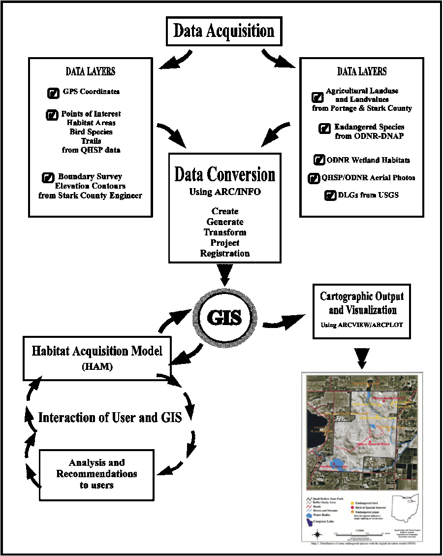
5.1 Data Layers Description
A GIS database of the park area and
surrounding landscape was created by digitizing data from maps and acquiring
secondary data in various formats from government agencies. Data layers
that were digitized include:
1. park boundary (used as the base layer) - from Stark
County Engineering Department map
2. points of interest - from QHSP map
3. trails - from QHSP map
Secondary data were obtained from
the ODNR, USGS and Stark and Portage county governments. The
secondary data layers include:
1. Agricultural Land Use and Land Values - from Stark and Portage County
government
Types of agricultural landuse can be identified as areas for
animal movement or forage. These areas may provide natural corridors
for animal migration which benefits biological diversity. The cost
of land under consideration must be within proposed or established
budgets. Land values often fluctuate and are difficult to determine.
2. Aerial Photography - from ODNR and Quail Hollow State Park
Aerial photography (remotely sensed imagery) was used in
land use analysis in a variety of ways. Boundaries of vegetation
and habitats were identified and digitized from imagery. Spatial
perspective and location were thus established. There are many
problems in converting and rectifying aerial photography for use in a GIS.
The solutions to these problems are discussed in Section 5.6.2.
3. Wetland Classifications - from ODNR, Wildlife Division
QHSP consists of a majority of wetland habitat types. Parcels
near the park with similar types of habitat would provide increased habitat
for species preservation and biodiversity. Parcels acquired in direct proximity
to the park would also serve as a buffer to the exposed' edges (ecotonal)
on the park boundary. Areas not in direct proximity might be eventually
connected' to the park system via habitat corridors. Wetlands that
are compatible with park habitats can be identified using GIS
overlay functions of buffering, intersecting and other spatial overlay
techniques.
4. Natural Heritage Data - from ODNR, Division of Natural
Areas and Preserves (DNAP)
The Natural Heritage data includes latitude and longitude coordinates
of locations of state-listed endangered plant species. These data
were overlayed on wetland habitats from ODNR to identify habitats within
QHSP that correspond with habitats in the buffer study area (BSA).
5. Digital line graphs (DLGs) - from the USGS
DLG data were used for transportation and hydrography information
in the park and BSA. The DLGs were converted from USGS 250,000 map
series digital data 6. Digital elevation model (DEM) - created by digitizing
the two-foot contours from Stark County Engineer elevation data
The topography of the park and study
area is shaded on a digital surface constructed from
contour elevations. Animal and plant locations overlayed on
the DEM can identify physiographic features preferred by some species.
The DEM data from USGS could not be used for the BSA due to errors in the
data and their low resolution.
SPECIAL NOTE: Throughout the chapters on methodology
I refer to many different command structures and parameters used
for processing and conversion of digital data and coverages. Unless
otherwise noted the commands pertain to ARC/INFO (ESRI 1996)
GIS software modules. These commands will be capitalized and in brackets,
e.g. [BUFFER]. For further information on software mentioned in this study
see Appendix C.
5.2 GPS Ground Control Coordinates
Perhaps the most critical part of an integrated
GIS database is the proper registration of data layers. For layers
in the GIS database to fit'together there must be a source of accurate
and precise geographically referenced coordinates to be used as the ground
control points. In ARC/INFO control points are generally referred
to as "TIC" points. For this thesis a Global Positioning System (GPS)
was used to obtain ground-truthed' control positions in the field (Morain
and Budge 1996).
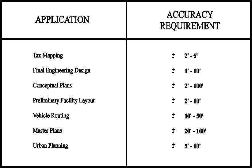
The degree of positional accuracy is often determined by the
intended use of a GIS (Montgomery and Schuch 1993). Accuracy requirements
can be generalized based on the application (Table
1). The GPS unit used was a Garmin GPS 45 hand held unit which
has a claimed accuracy of +-10 meters (Garmin International 1994).
The Quail Hollow State Park project is considered under the heading Conceptual
Plan. Positional accuracy in the study was maintained within 10 meters
(+- 32.8 feet) using the Garmin GPS unit.
Four control points were selected for
registering the data layers. In ARC/INFO the minimum number of
points (TICS) needed to register a coverage is four. The points were
chosen because three (points 1,7 and 11) are intersections of roads.
Point 2 is the intersection of the park boundary at a road (Pontius Street).
Alternate locations for control points would be a tree or building.
However, these types of locations could be destroyed thus making location
data useless. The four points chosen were considered reliable positions
in that they were likely to remain permanent and that they were easily
identifiable on the aerial photograph and other maps such as land ownership
parcels and the park survey.
The coordinates received from the Garmin GPS
unit were in degree-minutes-seconds (DMS) format. The DMS coordinates
were converted into degree decimal (DD) format using a Hewlett-Packard
(model 42S) handheld scientific calculator.
5.3 Digitizing and Registration of Data
The data layers of the QHSP boundary,
points of interest, trails, and elevation contours were created by
digitizing features from paper maps. The elevation contours were
digitized from the Stark County Engineering Department map of elevation
contours with two-foot intervals. Information on the digitizing techniques
for the elevation contours is covered in the digital elevation model
(DEM) discussion in section 5.5.
The points of interest and trails data were
digitized from maps supplied by QHSP management. Digitizing is a
very time-consuming procedure. Data sources, i.e. maps, were prepared
by highlighting areas or points on the maps, such as coordinates for TIC
locations. In ARC/INFO, TICS are "geographic control points
representing known locations on the earth's surface", (ESRI 1995).
These control points allow different data layers to be registered to a
common coordinate system, such as the Universal Transverse Mercator (UTM).
In this thesis all data layers were registered to the UTM coordinate system
with meters as the data unit.
Once TIC locations were established, the map
was taped to a digitizing table or tablet with an electronic grid'
built into the table. A keypad, with a number of buttons for
different operations, was used to enter x,y coordinate information.
A point coordinate is entered with just a single click on the keypad.
Lines are formed by entering numerous points to define the shape of the
line. Polygons are created by digitizing lines to define the boundary
of the polygon. The arc digitizing system (ADS) of ARC/INFO was used
for digitizing with digitizing units in inches.
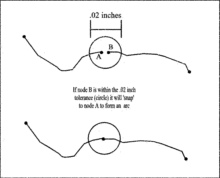
Digitizing snapping tolerances of .02 inch
were used on all primary data layers. This tolerance refers to the
beginning and ending points of arcs (lines) where they join at a node.
Figure 7 shows an example of digitizing tolerances.
Care must be taken to locate the tics as accurately
as possible. Accurate tic locations are especially critical when
re-entering tic coordinates at the start of each digitizing session.
The ARC/INFO ADS calculates the root mean square (RMS) error whenever tics
need to be re-registered. The RMS error represents the amount
of error between original and new coordinate coordinate locations.
The lower the RMS error, the more accurate the digitizing or transformation.
All primary data layers were within .004 inches of RMS error.
When digitizing was complete procedures were
used so the topology among digitized objects was established for all data
layers. Topology is defined as the spatial relationships between
connecting or adjacent coverage features , e.g. arcs, nodes, polygons,
and points (ESRI 1995). The tics of the QHSP boundary coverage were
extracted into a dummy' coverage using [CREATE]. Real-world coordinates
in degree decimal format were input in [TABLES] to update the tic locations.
These coordinates were obtained with the Garmin GPS unit (Section 5.2).
The dummy' coverage in degree decimal (geographic) coordinates was
then projected into UTM meters. Using the [TRANSFORM] command
in ARC/INFO, the coordinates in inches in each coverage were converted
into UTM projected coverages.
5.4 Acquisition and Conversion of Portage and Stark County
Data
The acquisition of secondary data and subsequent
conversion procedures were significant tasks in the creation of the GIS
database for Quail Hollow State Park. Some of the most extensive
problems occurred with the land value and ownership data needed for the
habitat acquisition analysis. The north property line of the park
rests on the political division between Portage County to the north and
Stark County to the south (the entire park area is in Stark County).
However, the habitat acquisition analysis required some delineation of
a delimited study area with proximity to the park. A buffer study
area (BSA) was established around the park boundary using the [BUFFER]
command in ARC/INFO (as described in Figure 3).
Parcels considered for acquisition within this buffer area (named
QHBUF) were selected based on selection criteria of land use and
land cover data from both Stark and Portage Counties.
This brings up the interesting and often frustrating
problem of the lack of consistency of data format between different government
agencies. The land use data for Portage County were acquired from
the county auditor's office. The attribute data for parcels in the
buffer area were acquired in DBASE format from the Portage County Data
Processing Center. The property boundaries for Portage County were
only available in paper map copies and had to be purchased from the Portage
County Tax Map Department.
Stark County data obtained from the
county auditor's office were in somewhat reverse formats. Property
boundaries were in DXF (Drawing eXchange Format) converted from CAD (Computer
Aided Design) software. CAD software can be used to create vector
(line) drawings with symbols and text and is often used in engineering
applications to plan road construction and property maps (Montgomery
and Schuch 1993). CAD drawings do not represent a topology'
or specific geographic relationship of features and objects to one
another as a GIS package does.
CAD data and GIS data are fundamentally different
in that CAD data have one attribute per layer while GIS data may have multiple
attributes associated with a layer. The DXF format is an export format
that ARC/INFO can translate into a topological coverage. Each DXF
file contained a quarter section based on the Public Land Survey
System (PLSS) (Huxhold 1991). Figure 8
shows a typical CAD drawing containing layers of property boundaries, parcel
numbers and other descriptive information.
Accuracy of the data from both Portage and
Stark counties was questionable. The Stark County data had land values
for the period between 1989 and 1994. Land values tend to fluctuate
with market value. Communication with both county governments suggest
the land values were actual (total) value rather then tax value.
The conversion process continued until the data could be visualized
and interpreted for accuracy and reliability.
Conversion of CAD DXF files into ARC/INFO
is a two-step process. To determine the type of data storage (i.e.
lines or annotation/text) the command [DXFINFO] is first used. This
extracts from DXF files what information can be processed by ARC/INFO.
While this is useful information there is an another way to visualize the
CAD layers. The DXF files can be imported into CORELDRAW software.
Both techniques were used in this study to confirm property boundaries
and parcel numbers.
The command [DXFARC] was used to convert DXF
files to create an ARC/INFO line coverage. This coverage was brought into
ARCEDIT where the polygon labels were reassigned to provide links' to
the attribute files previously entered into DBASE. The label
points of each polygon are stored as a feature-id in the .PAT (polygon
attribute table) or .AAT (arc attribute table) data files in the resulting
ARC/INFO coverages. Therefore, they may be used to identify
each polygon or arc by their identification attributes. For example, in
the Stark County parcels coverage which was named STARK, the feature
identification in the .PAT would be STARK-ID. In ARC/INFO,
these identical identifier items were linked or joined with the command
[JOINITEM]. All subsequent queries of a polygon (or arc) contained
all attributes from the DBASE database.
The Portage County ownership parcel maps were digitized
using PC ARC/INFO and then converted to workstation ARC/INFO via the export/import
function to take advantage of the faster processing speeds on UNIX platforms.
The Portage and Stark parcels coverages were assembled into
two separate coverages using [MAPJOIN]. These were named PORTAGE
and STARK respectively. The Portage coverage contained 120 polygons
(parcels) and the Stark coverage contained over 300 parcels. Finally,
the attribute information from each county database was linked to the coverages
using [JOINITEM] as explained above.
While this conversion was very time-consuming,
it was necessary to obtain the land use data. The STARK and
PORTAGE coverages were then delimited to the buffer area using the [CLIP]
function in ARC/INFO. Parameters for the [CLIP] command are
the coverage to use as a cookie-cutter' (the buffer QHBUF coverage) and
the coverage to be clipped (STARK and PORTAGE coverages). The resulting
coverages (STARKBUF and PORTBUF) contain polygons and their attributes
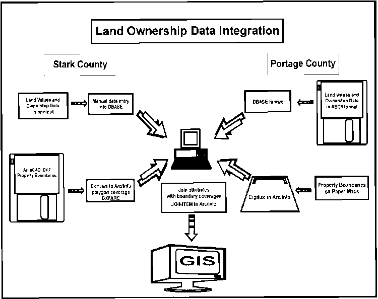
of land use and land value for the study area. Figure
9 shows the land ownership data integration process. These coverages
were later intersected with the ODNR wetland habitat coverages (described
in section 5.7.1) to produce a comprehensive GIS database for the
habitat acquisition modeling.
The land value information was questionable
as to whether it pertained to assessed land value or actual land value.
Land values tend to fluctuate with current market value. It is not
reasonable to assume that the land values from 1988 to 1994 data would
be current values. Land value would have to be determined at the
time of acquistion or contractual agreements. However, it is expected
that the relationship between land values among available parcels will
remain steady over time. Once conversion was complete the data was
displayed in ARCVIEW to visualize the land value information. Values
of land appeared to be assessed values. Therefore, the land value
information was not considered in the acquisition model or other analyses.
The data conversion procedures were especially
time-consuming due to the conflicting formats of the data from the two
county governments. Many government agencies are beginning to use
ARC/INFO as the bridging format for land parcel information. It is
likely in the future that more agencies will be able to provide data in
ARC/INFO format, thus eliminating the time factor (and cost in real-world
applications) in data conversion.
5.5 Digital Elevation Model (DEM)
A digital elevation model (DEM) was constructed
as a visual tool for surface representation and modeling. The DEM
was also necessary for the proper registration and rectification for the
ODNR aerial photography (see Section 5.6.2).
A paper map of two-foot elevation contours
was obtained from the Stark County Engineer's Department (scale 1" = 200',
created 1970). Elevation in the park ranges from 1130 feet
to 1220 feet. While this map had no available accuracy documentation
it was used for three reasons. First, it was a readily available
source (the map was provided free by Stark County). Secondly, the
map's large scale (1:200) enabled contour lines to be digitized with better
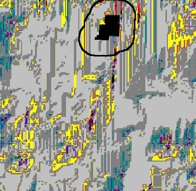
accuracy. Finally, the USGS 250,000 DEM covering the park area
contained striping' areas with large gaps of missing data in the geographic
are of the park and BSA. Figure 10 shows the
large number of scanning errors. It was unfortunate that the
USGS DEM data could not be processed for this study. The USGS DEM
data would have provided an easy source for Z values (altitude) and visualization
of topography in the entire BSA.
The Stark County map was digitized in
ARC/INFO ADS (arc digitizing system) using digitizing snapping tolerances
of .02 inch (refer back to Figure 6). Each
contour was marked with a unique color pencil prior to digitizing.
The elevation of similar contours was assigned to the arc user-id. Arcs
with similar id numbers were calculated as spot height elevations for input
to ARC/INFO [TOPOGRID] module. TOPOGRID is an interactive module
in workstation ARC/INFO that creates highly detailed DEMs from many different
source inputs.
There are two requirements for the TOPOGRID funtion to create
a DEM. First, a [BOUNDARY] coverage must be available. This
can be any coverage that is representative of the area from which the DEM
will be interpolated. The only other requirement for TOPOGRID is
the [CONTOUR] coverage and the item identifying the spot height for each
line contour. This was the digitized coverage from the Stark County
Engineer's map.
In addition to the spot height parameter in TOPOGRID, the program
also allows for concurrent input of a drainage line coverage. This
coverage helps enforce proper drainages and sinks (low areas) in the DEM
creation process for more accurate terrain representation. This option
was used in the TOPOGRID input. The [DRAINAGE] coverage contained
the streams within the park digitized from the Stark County Engineer
map.
The resulting DEM is a grid (lattice) that can be displayed
in two-dimensional form or as a three-dimensional surface.
The [HILLSHADE] command in ARC/INFO was used to provide shading of
the topography. In addition, increasing the Z factor (height of elevation
points) by a factor of 1.5 helped enhance the minimal topography changes
within QHSP.
5.6.1 Aerial Photography - First Attempt
A color aerial photo of the entire park
was incorporated into the GIS as a visual representation of the immediate
park area and the adjacent land patterns. The photo was rasterized
by scanning on a Microtek Scanmaker IIHR color scanner. The
original photo dimensions were 24" by 18". Since the scanner used
was only able to accommodate 8"x10" at a time, the photo had to be scanned
in 9 separate sections. Each image was acquired through the use of
Micrografx Picture Publisher (Micrografx,Inc. Richardson, Texas) software
running on a 100mhz Pentium PC with 16 MB RAM.
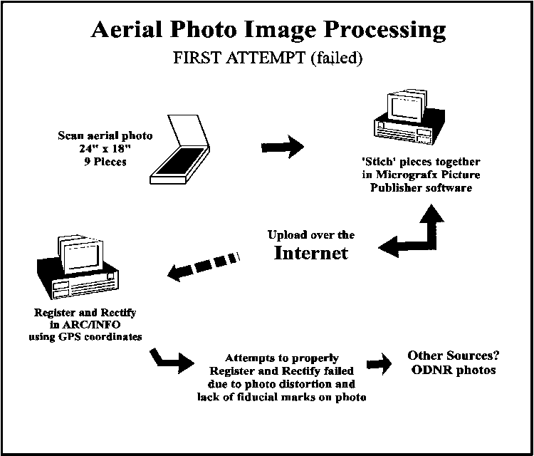
Figure 11 details
the steps in the attempt to register the color aerial photo.
As each image was acquired it was "stitched" (Micrografx,Inc. Richardson,
Texas) to the previous image. This stitching function involved the
matching of two distinct points on each image. Melding of the raster
pixels was based on these two point locations. Average file size
of each image piece' was 1.5 megabytes (MB) at a resolution of 150 dpi
(dots per inch). The final image size was 10.8MB.
Once the image was assembled, it was necessary
to upload or send the image via FTP (file transfer protocol) to the UNIX
based workstation for further processing into ARC/INFO format. The UNIX
workstations utilized for this study were Hewlett Packard Apollo 9000 model
730 running as a server at Kent State University Department of Geography,
Kent, Ohio. Download time was 1.5 hours at 14,400 bps (with current
higher speed modems of 28800-55600 bps the download time would be
reduced dramatically) .
The Image Integrator module of ARC/INFO was
used for the attempt at integration of the photo into the GIS.
The Image Integrator allows for registration of image files to real-world
coordinates. Coordinates are linked' to image points by either
manual entry or to points on an ARC/INFO polygon coverage. Once the
image is registered, it is warped to fit coordinates using either [RECTIFY]
in ARC/INFO or [MAPWARP] in ARCPLOT. There was a problem in
this conversion in that the photo would not register correctly with the
digitized park survey boundary. The boundary survey was used in the
attempt to register the
photo because it was already registered to GPS coordinates. The
registration difficulty was due to two factors 1) the distortion
in the aerial photo image; and 2) lack of fiducials for location
of the central point of the photo (see Literature Review section
3.3). Distortion problems existed in the original photography and
further distortion may have occurred in the joining of the multiple scanned
images.
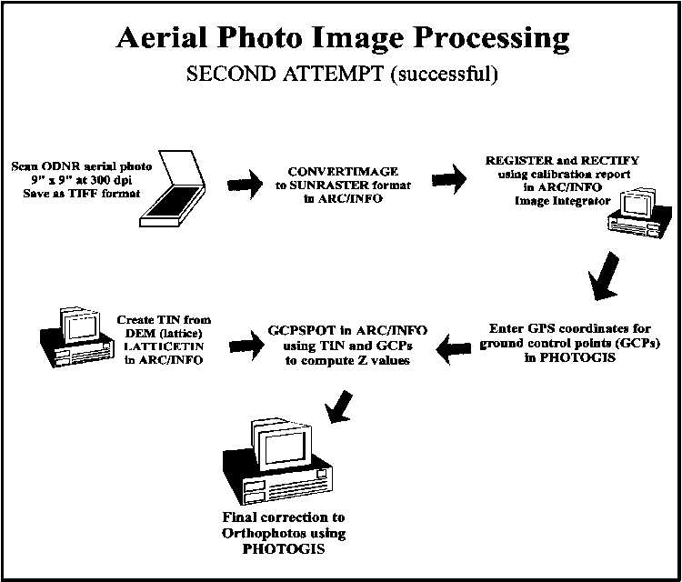
5.6.2 Aerial Photography from ODNR - Second Attempt
With the failure of the registration process
of the QHSP color aerial photo, it was necessary to obtain aerial photography
from another source. A request for photos was made to the ODNR Earth
Science Information Center (ESIC) in Columbus, Ohio. Black
and white (B&W) photos were ordered from ODNR covering QHSP and
the BSA. The flight dates of the photos were 4-19-95
(scale = 1:12000) and 4-16-85 (scale = 1:24000). The ordering
process required 6 weeks and the photographs were a significant cost to
the project. The registration of the B&W photos began in a similar
fashion to the process for the color photo (see
Figure 12). The 1995 and 1985 photos were scanned on a 10" X
10" flatbed scanner at a resolution of 300 dpi using ADOBE PHOTOSHOP
software. The image file was saved in Tag Image File Format (TIFF)
and then converted into SUNRASTER format using ARC/INFO [CONVERTIMAGE].
TIFF format is used in desktop publishing applications. SUNRASTER
format is a specific image format for Sun Microsystems operating system.
The conversion was necessary because the orthophoto
conversion software required SUNRASTER image format. The resulting
binary file of just one 9" X 9" B&W photo was approximately 7.5 MB.
The 1985 photo at 1:24000 scale covered the entire BSA. There were
4 different photos scanned in the 1995 series at 1:12000 scale.
After correction and joining of the 1995 photos,
it was discovered that the BSA was not entirely represented. Due
to time constraints and budget limitations, the additional 1995 photos
were not ordered. Additional photos to complete the BSA would have
required another 3-4 weeks. The 1995 photo was used for detail maps
of QHSP and the 1985 photo series was used for the BSA maps and the Habitat
Acquisition Model (HAM).
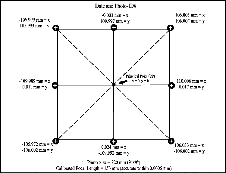
A major advantage in the processing of the
ODNR photos was the presence of fiducial marks. Fiducial marks
define the photo coordinate axes (refer to Literature Review Section 3.3).
A line drawn from northwest to southeast fiducials intersects a line drawn
from northeast to southwest fiducials. The central point where
these lines intersect is the principal point which serves as the anchor'
point for x,y, and z corrections in the photo. Each fiducial
mark must be referenced to a coordinate obtained from a camera calibration
report. The ODNR could not provide the calibration report.
Camera models can be determined by the type and locations of fiducial marks
(Oregon State University 1994) it was determined that the camera used was
a Wild RC10, a common camera used in aerial photography. The calibration
report used for the fiducial coordinates was obtained from the USGS in
Reston, VA (U.S. Geological Survey 1992) (see Figure
5, Section 3.3).
The fiducial coordinates were entered into
a text file. The text file was used with the ARC/INFO [GENERATE]
command to create a coverage of the fiducial coordinates (PHOTCOV).
The scanned aerial photo image was entered into the ARC/INFO Image Integrator
module using the [REGISTER] command. The PHOTOCOV coverage
of calibration coordinates was used as a tic cover to link to the
fiducial marks on the photo. Registration accuracy (RMS error) was
computed by ARC/INFO to be less than .001 mm. The registered photo was
rectified using ARC/INFO [RECTIFY] command.
ORTHO-PHOTOGIS (GBS Tasmania, Australia) image
processing software was used for the conversion of the rectified
photo into a digitally corrected orthophoto. ORTHO-PHOTOGIS is an
independent program that functions within ARC/INFO. Using the
GPCEDIT module of ORTHO-PHOTOGIS, the GPS coordinates obtained earlier
(Section 5.2) were used to reference known point locations, such
as road intersections, that were clearly visible on the image.
The digital elevation model (DEM) created
in the previous section was important in the conversion of
the aerial photos to digital orthophotos. The DEM contained x,y and
z values in a grid format, i.e. a lattice of point coordinates. ARC/INFO
uses the words GRID and LATTICE interchangeably. They are essentially the
same.
ORTHO-PHOTOGIS requires a triangular irregular
network (TIN) for the final ortho correction. A TIN is a digital
surface model that estimates a terrain surface with a set of triangular
facets (Lee 1991). The DEM grid was converted to a TIN using the
[LATTICETIN] command in ARC/INFO. This ORTHO-PHOTOGIS uses
the TIN and the x,y coordintes from the previous established ground
control point (GCP) file to calculate x,y,z values for
the entire photo area.
The final program entry necessary to complete the transformation
of the photo into a digital orthophoto was the focal length of
the camera which was calculated at 152.95 mm (U.S. Geological Survey 1992).
The ORTHO-PHOTOGIS computed the accuracy of the orthophoto correction at
+- 5 meters.
The completed 1:24,000 scale 1985 orthophoto
was easy to clip to the BSA since the BSA was entirely within the
photo boundaries. The 1:12,000 1995 orthophotos required a number
of steps to merge them into the final image. In both circumstances,
the finished orthophoto(s) were converted to grids using ARC/INFO [IMAGEGRID].
Each grid (lattice) was resampled to the same cell size of 1 meter.
[LATTICEMERGE] combined the four 1995 photos into one photo mosaic.
[LATTICECLIP] was used to clip the photos to the BSA or the QHSP
boundary area. Finally, the merged grids were converted back to images
using [GRIDIMAGE] and the SUNRASTER format option. The SUNRASTER
image format is accepted by ARCVIEW for displaying images.
5.7.1 Wetland Habitats from ODNR Division of Wildlife
Secondary data of wetland/habitat types
for Stark and Portage counties were obtained from the ODNR Division of
Wildlife. The data were pre-processed by ODNR from satellite
imagery using ERDAS (ERDAS Inc. Atlanta, Georgia) image-processing
software. ERDAS is a raster and vector GIS package which
is used for processing of raster data into a useable
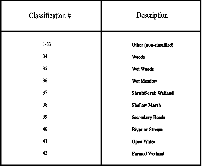
GIS format. The ODNR data layers contained 44 items related
to wetland habitat as well as political boundaries, such as roads, lakes
and rivers and non-classified areas. Wetland classifications are
based on Anderson, et al. (1976) and Shaw and Fredine (1956). The
first 29 data attributes were non-classification values. The remaining
15 data attributes available were classified as shown in Table
2. The files were downloaded from the ODNR ftp site dnr.ohio.gov/wildgust.
The ERDAS image files were received in binary (raster) format and registered
in UTM coordinates. The classification values were assigned to individual
pixels (cells). A number of conversion steps had to be accomplished
before the coverage could be useful in the GIS.
First, the images were converted into GRID
format in ARC/INFO using the command [IMAGEGRID]. Then, the
[GRIDPOLY] command was used to convert the GRID cell format into
a vector format. This conversion to a polygon coverage was necessary
so that they could be overlayed later (using [INTERSECT]) with the STARKBUF
and PORTBUF land parcel coverages for the habitat acquistion model.
While this was necessary, it was not preferable since raster to vector
data conversion usually results in some loss of clarity. The conversion
from raster (cells) to vector (lines) results in a blockiness'.
This is especially noticeable in the roads or rivers which are usually
delineated as lines. Parcels or polygons are less noticeable because
a polygon has a square area which is well-represented by the square areas'
of the raster cells.
After being converted to a polygon coverage,
the wetland classifications were listed in an item called GRID-CODE.
For clarification, a new item was added to the polygon attribute table
(PAT) called ODNR-CODE. The values for GRID-CODE were assigned to
ODNR-CODE using the [TABLES] (INFO) command [CALCULATE]. To assign
descriptions to link to the ODNR-CODE, another item ODNRLU was created.
A [RESELECT] of each ODNR-CODE value was then related to the ODNRLU landcover
descriptions using the [TABLES] command: e.g. MOVE WET WOODS' to
ODNRLU. Later this coverage was intersected with the agricultural
land use coverage. The intersected polygons then contained both attributes
of wetland habitats and also agricultural landuse.
5.7.2 Natural Heritage Data for Endangered Plant Species
Natural Heritage data of endangered plant
species in Ohio were obtained from ODNR Division of Natural Areas and Preserves
(DNAP). Natural Heritage programs have been established throughout
all 50 states. Natural Heritage programs collect, manage and
use biological, ecological and related information in cooperation with
various state agencies. The criteria for Natural Heritage data are based
primarily on the goal of protecting biological and ecological diversity.
The data format was a text file of 61 endangered plant
species locations in the geographic area near Quail Hollow State Park.
An example of the text file attributes is shown in Table
3.
The comma-separated data describe geographic and
descriptive point locations for plant species. A number
of steps were necessary to convert the text entries into a useable ARC/INFO
point coverage . The first two entries are latitude and longitude
in degrees, minutes, and seconds (DMS).
An easy conversion solution was to import
the textfile into a spreadsheet program. Quattro Pro ver. 6.0 (Corel Corp.
Salinas, California) spreadsheet program was used but any other spreadsheet
program would suffice. Cell conversion was quite simple with each
data entry contained in a spreadsheet. The unnecessary N's, W's
and 0's in the latitude/longitude coordinates were deleted
using global search and replace. Conversion of DMS lat/long
to DD was accomplished by entering a formula, (Decimal degrees = Degrees
+ Minutes/60 + Seconds/3600) and copying it to each cell. Longitude
was multiplied by -1 to calculate degrees west of the prime meridian.
The latitude column was cut and pasted in order after the longitude
column. An identification number field as added to precede longitude
and numbers entered from 1 to 61.
Conversion into the ARC/INFO point coverage
was completed using the [GENERATE] command. The coverage was projected
into UTM.
5.8. DLGs from the USGS
Digital line graph (DLG) data (scale 1:250,000)
was downloaded from the USGS ftp site ftp edcftp.cr.usgs.gov/pub/data/DLG/250.
Roads, railroads, and hydrography files were downloaded in binary compressed
format for canton-e (Stark County) and cleveland-e (Portage
County). Most of the USGS data such as the DLGs and DEMs are very
large files (often in excess of 10 megabytes) and require pre-processing
before they can be used in ARC/INFO (UNIX is the preferred operating system
environment). An unblocking command sequence is used to reorder the
data into an ASCII block configuration. An example syntax for the
USGS DEMs at UNIX prompt is dd if=<filename> of=<new filename>
ibs=8000 cbs=1024 conv=unblock. For specific unblocking instructions
there are README files in the directories for each category of data (i.e.
DLG, DEM, LULC, etc.).
The files were brought into ARC/INFO
using the command [DLGARC]. Once the ARC/INFO coverage is established,
the file must be projected into the appropriate datum. All coverages
for this study were projected in UTM (Universal Transverse Mercator) using
the ARC/INFO parameters for the [PROJECT] command. The resulting
coverages from the DLGs were roads, railroads and hydrography.
These covers were used as overlays with a number of maps to define relative
location and reference for the transportation and hydrography in the BSA.
5.9 Methodology Summary
Throughout this chapter on methodology,
descriptions of the numerous data manipulations and conversions have displayed
the complexity of compiling the GIS database. Obtaining the files
and data and the lengthy time factor in conversion are the basic' steps
in making data useable for input into the ARC/INFO GIS. The time
factor translates into significant costs for data conversion. In
addition, there was substanial cost incurred for data that proved to be
unreliable and unusable. There are many secondary data sources available
from government agencies. Sources used in this research were the
ODNR ERDAS images from Division of Wildlife, the ODNR DNAP Natural Heritage
Data, and the DLGs from the USGS. Data sources, such as the
digitized contours from the Stark County engineer map, were used to create
the DEM.
Aerial photography is a useful tool for reference
of a study area and delineation of habitats and GPS coordinate locations.
The time to scan, register and rectify aerial photography is very extensive,
again translating into amplified costs for a project. Distortion
in an aerial photograph may render it unusable for the overlay of geographically
referenced data. However, an aerial photograph can also be used as
a single data source identifying land use and other geographic relationships
in a region.
The spatial analysis functions such as buffering
and intersecting are useful for limiting an area of study and allowing
queries of attributes from different data sets. The following chapters
demonstrate the results of the data conversions and habitat acquisition
analysis applying spatial overlays and queries using ARCVIEW
GIS software.